
![Perge [EN]](https://www.aahmetyildiz.com/wp-content/uploads/gezi/turkiye/antalya/20190428_perge/main.jpg)
Perge is 18 km to the east of Antalya on the border of Aksu district. It is one of the most well laid out of Roman cities, not only in the Pamphylian Region but in the whole Anatolia, with its characteristic structures and built to a planned city model. From the inscriptions based upon an old tradition and dated 120-121 AD recovered in 1953 in the city gate courtyard dating from the Hellenistic Period it was recorded at that time in the second century AD that the Achaeans came to the Pamphylian Region where Perge is located.
Perge is 18 km to the east of Antalya on the border of Aksu district. It is one of the most well laid out of Roman cities, not only in the Pamphylian Region but in the whole Anatolia, with its characteristic structures and built to a planned city model. From the inscriptions based upon an old tradition and dated 120-121 AD recovered in 1953 in the city gate courtyard dating from the Hellenistic Period it was recorded at that time in the second century AD that the Achaeans came to the Pamphylian Region where Perge is located. There are seven of these inscriptions, written on the statue bases inserted most likely in the upper row of the two-storeys of niches on the walls surrounding the oval yard, which can be closely related to the Perge Akhaean colonisation period. Although the sculptures that stood on these bases have not survived to the present day, the statue bases are in good condition. The names of the Akhaean heroes: Riksos, Labos, Kalkhas, Makhaon, Leonteus, Minyas and Mopsos can be read recorded in these inscriptions, the legendary Akhaean founders of the city. When examined the origins of the ktistes on these inscriptions and considering philological research, it was determined Perge was an Achaean colony in the 12th century BC. It is also related that after the Trojan War some Greek heroes chose the western Anatolian coasts for returning to homelands with Kalkhas, Leonteus, Amphilokhos, Polypoties and Podaleirios are among them. Therefore it is understood that five of the seven heroes of Perge were I amongst those who built cities in Southern Anatolia after Trojan War.
However, from research conducted on the Perge acropolis, Perge has a prehistoric past that dates back to the Late Chalcolithic Period (5th millennium BC) and employed the ceramic repertoire of the Western Anatolian Bronze Age in the 3rd millennium BC had been an area of settlement from the prehistoric age onwards. Also from the cuneiform inscriptions in Hittite language on a bronze plate found in excavations in 1986 in Hattusas (Bogazkoy/Corum), the capital of the Hittite Empire, much significant information was acquired. It is understood this bronze plate carries the text of a treaty between the Hittite King Tudhalia 4 (1265-1215 BC) and the vassal king Kurunta that Perge was a well-known and a very important place at this time during Hittite Empire. It records: “The region of the Parha city is bordered by Kastarja River and if the Hatti King draws an area for it and rules the city of Parha by armed force, the city will be attached to the Tarhuntassa King” and the word Parha is understood to be the name of Perge at this time and the Kastarja River the later Kestros and today the Aksu River.
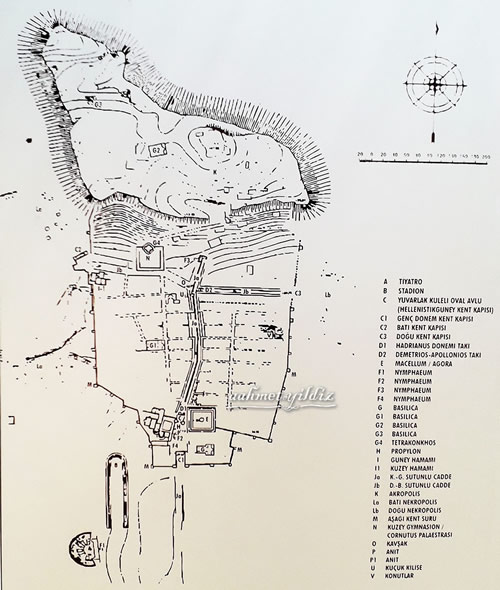
The research and excavations conducted to the present day show the city experienced glorious days in different periods. The first of these was during the Hellenistic Period represented by the magnificent towers (3rd-2nd century BC). During Alexander the Great’s capture of the region in 333 BC, the people of Perge welcomed Alexander’s forces without any resistance is thought to be due to the nonexistence of the city walls. In the subsequent Roman Period the city of Perge employed the long period of peace and economic prosperity provided by the Roman Peace, the Pax Romana, to construct many major public buildings, including the theatre, stadion, agora, monumental fountains and baths which still remain visible today. The last glorious period for the city of Perge in history was in the 5th and 6th centuries AD, when the Roman Empire was a Christian empire and the city became a metropolitan centre in the church organization and monumental basilica were built.
Perge is located on the route of the ancient road that began in Pergamon and ended at Side and the city owes its development to its location on Aksu (Kestros) River. This river, in addition to fertilising the soil through its regular flooding of the surrounding fertile alluvial plain, was in antiquity suitable for marine transportation, providing international maritime access to the city. St. Paul and his companions are known to have sailed from Baf (Paphos) Harbour in Southern Cyprus to reach Perge via the Kestros River. The river’s importance for the city can be clearly understood from the depiction of the River God Kestros on the city’s coins, reliefs and in the statue of which can be seen today in nymphaion situated on the southern side of Acropolis.
Amongst the figures of historical importance from Perge was Apollonius of Perge famous for his work in astronomy, geometry and mathematics. Another was the second century AD sophist Philosopher Varus of Perge. Although many gods and goddess were worshiped in antiquity, Artemis had a special place and importance for the city. Artemis whose origin is buried in the mists of time, was mentioned as Wanessa-Preiia (the Perge Queen) in the local language was the main goddess of the city. The cult of the goddess termed Artemis Pergia as the city expanded, was worshiped in neighbouring cities and overseas. The Temple of Artemis at Perge was magnificent in terms of its size, elegance and construction stood on a high hill outside the city but its physical location has not been determined yet.
In 2009 the archaeological site of Perge was recorded in the UNESCO World Heritage Tentative Lists. The excavations which had been conducted since 1946 by Istanbul University Archaeology Department, since 2012 have been conducted by the Antalya Museum on behalf of Culture and Tourism Ministry of Turkey.
Stadium
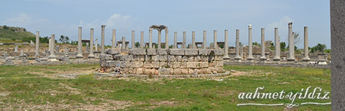
This structure near to the theatre of Perge, is likewise located outside the city walls, and is one of the best preserved stadions surviving from antiquity today. It is orientated on north-south direction and was constructed from by using ashlar limestone blocks, from the local stone quarry on a smoot area, with bossage on a level ground and with the tiers of seats supported by vaults. The south part of the structure is opened and the sphendone facing the north has the form of an apse. The total length of the stadion is 234.00 m. and curvature appears in the middle section. The running track approximately 34.00 m. wide was separated by a wall constructed at a later date. There are five gates to this arena: one in the north, two in the east and two in the west and there are 8 vertical stairs with 22 steps in arena section.
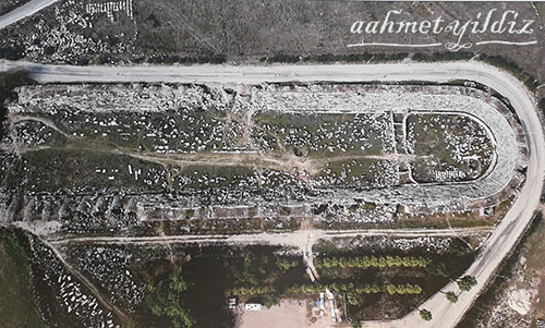
It was constructed upon 70 arched subsection structures: 30 in each long side and 10 in the short side and thereby forming 11 rows of seat. The height of each of the seat rows is 0.436 and their width is 0.630 m. On the top, there is an open area level 3.70 m. wide that consists of spaced rows.
The vaults in the north, east and west of the structure face outward. These stable vaulted support structures, each approximately 5.70 m. wide and 9.84 m. deep, are thought to have been used as stores or workshops for economic production and for commercial activities.
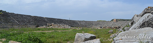
It is thought that construction of the stadium began in the second half of the first century AD and has the capacity to seat approximately 12.000 people.
The Roman Gate
While there are many side gates which were built during the construction of the city walls, Perge has three main gates, those in the south, west and east. Situated in the southern part of the city, two of them date from the Hellenistic and Roman Periods. Nearly 72.00 m. long the Septemius Severus Square is between these two gates. The gate which is called The Roman Gate and which is thought to have been built at the end of the 2nd century or at the beginning of the 3rd century AD is one of the most impressive monuments of the city.
Nearly 24.00 m. long the Roman Gate is a part of the large defence system constructed in the Roman Period that surrounds the city. The preserved height of the gate is almost 10.00 m. and there are five niches in the northern front facing the square. The spaces between these niches were also decorated with smaller rectangular niches. The niche in the middle is used as an entrance to the large city square today. This structure which is decorated with vaults, architectural ornaments and statues of extraordinary beauty on the north that emphasises the glory and the prestige of the city was also supported inorganically in the south façade by two symmetrically positioned towers.
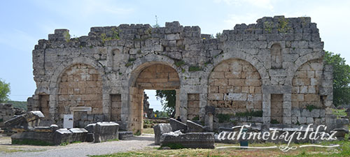
On the other hand; the north facing inner side of the gate gained monumentality with Syrian type tympanon made of marble and added in the 3rd century AD.
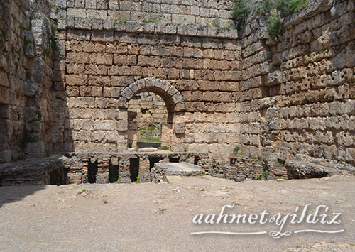
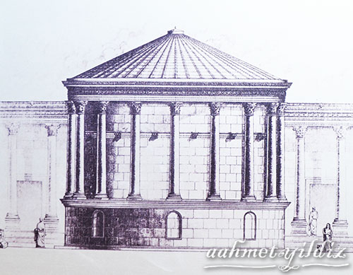
The Nymphaion of Septemius Severus
Many buildings associated with the water supply to the city were constructed in order to meet the increasing water demand of the growing city during the Imperial Period. One of these buildings is a remarkable structure added to the east of Southern Bath during the reign of the Emperor Severus and this nymphaion, one of the noteworthy structures of Perge, was named after Emperor Septemius Severus due to his imperial visit to the city.
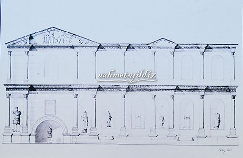
This two storey structure carries an inscription on the niche where the statue of the hunter Goddess Artemis is located. This inscription records it was dedicated to Artemis Pergaia, Emperor Septimius Severus, his sons Marcus Aurelius Antoninus (Caracalla) and Geta, also to empress lulia Domna and to the city of Perge.
The facade is supported by parapets with semi-circular basins. The round-arched niche situated to the south of the nymphaion and thought to have been constructed at an earlier date was also integrated into the complex during this phase of construction.
On the facade, the broken pediment with tritons on the corners, Helios and Selene in middle and in the centre from the left depictions of: Hermes, the Three Graces, Artemis portrayed as huntress, Artemis Pergaia, Aphrodite and Eros, are today in the Antalya Museum.
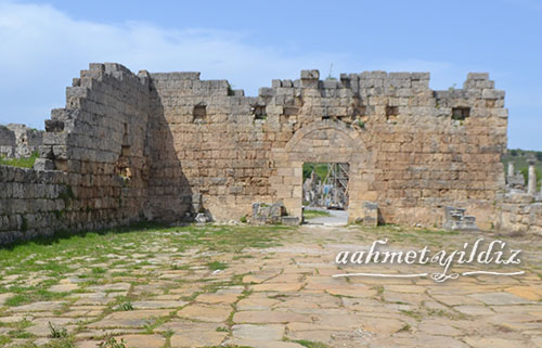
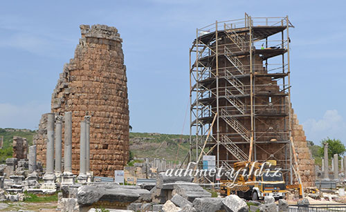
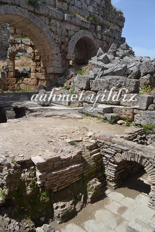
The Hellenistic City Gate and Towers
The Hellenistic City Gate situated in the north of the Septimius Severus Square, constructed of large limestone blocks is one of the oldest and remarkable structures of the city standing today. It dates from the 3rd century BC comprising two oval towers designed symmetrically, supported by vaults. Behind these towers there is a 23.00 x 30.00 m. horseshoe (U) shaped courtyard which is surrounded by high walls adjacent to these towers.
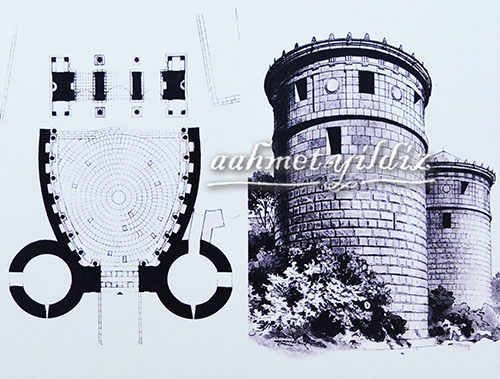
The three storey oval towers preserved to its original height had an important role in the defence of the city during the Hellenistic Period. Some extensions and additions were made during Roman Period with an ornately decorated arched gateway constructed between these two towers. This city gate is ornamented with pilaster capitals and has an architrave decorated with a triglyph and metope frieze and together with this new gate.

The walls which surround the courtyard visible on both sides of the towers were also lately constructed and in the upper and lower parts of these walls there are a total of 28 niches. The inscribed statue bases found in these niches suggests the decoration of this courtyard was designed to serve the purpose of political propaganda. This because the names of the legendary founders of the city and the Roman noble benefactors who had given financial support to the development of the city of Perge are written on these inscriptions, linking through association the supposed Akhaean founders of the city with the new rich nobility of the Roman city.
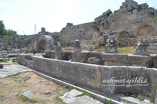
The Southern Bath
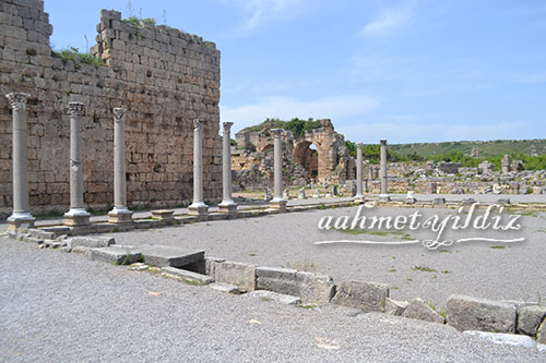
The Southern Baths complex is one of the city’s two major bath complexes. It was excavated between 1978 and 1985. These baths are orientated extending in sequence in a north-east/south-west direction, without a symmetrical plan, consisting of four main sections: apodyterium, frigidarium, tepidarium and caldarium. The Southern Baths consists of a series of adjoining rooms as in other Roman Baths houses in the Pamphylia Region as elsewhere. Guests first visit the apodyterium serving as the changing room with shelves on the walls. The apodyterium follows a largely rectangular plan and has stone and wooden seating. Next to this section is the swimming pool, natatio most probably used as a cleaning area after fitness training in the palaestra. The next room is apsidal in plan containing the cold bath (frigidarium). This section is followed by the warm bath (tepidarium), the Hypocaust where the heating system (collapsed) was located and the hot bath (caldarium).
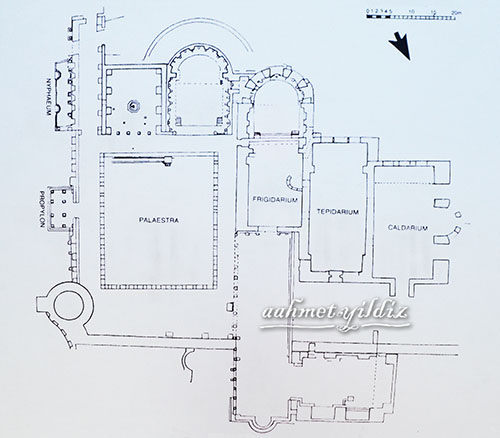
After the propylon on the east, the young people progressed to the palaestra for physical activities. To the north of the palaestra, there is a section called the Claudius Peison Gallery referring to the inscription found on the pedestal of the statue in the hall, with an arched gate passage from the frigidarium.
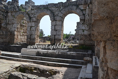
The Southern Baths experienced different phases of construction and is dated to the first to second centuries AD. Excavations show that the floors were adorned with mosaics and the walls were covered in marble plaques in the 4th century AD. The Southern Bath was embellished with the sculpture group known as ‘three graces’ and the statues of priestesses, together with sculptures of the famous figures from Greek mythology such as Athena, Aphrodite, Nemesis, Hygieia, Asklepious and Genius, which would have looked like an art gallery at the time when the Southern Baths were in use.
Propylon
Forming the elaborate entrance to major public buildings during the Roman Period, propylons (monumental gate) are structured to provide for a zone of transition in the passage to and from the main building.
The propylon designed symmetrically to embellish the east fagade of the Southern Bath was added to the bath during the oval courtyard rearrangement by the Hellenistic Towers in the reign of Emperor Severus. It was constructed upon a two-step marble covered platform. The smooth granite columns with square pedestals have Corinthian style capitals and the upper part of the structure was adorned with geometric and floral decorative reliefs. The excavation of this monumental gate was completed in 1969. According to its legend and the stylistic charactristic of the structure, the Propylon has been built during the period of Septemius Severus (AD 197-211).
Agora
The Agora of Perge within one of the most well-designed and planned cities of Roman Anatolian provides an example of this type through its plan and structural characteristics. The Agora positioned to the east of the Hellenistic Period Gate is surrounded by a wide stoa and there is a paved area surrounded by columned galleries. There are shops behind the galleries paved with ornate floor mosaics. Unlike the contemporary examples in Anatolia, the doors to the Perge Agora stores were arranged to open towards inside or outside alternatively. The entrances are in the centre of each of the four porticos. The open area on the western side these structures was employed as a main entrance hall. Given the natural slope of the area, it is possible to say that the south side of the Agora was of two storeys.
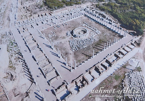
The place termed the Agora (Bazaar) was subsequently called as the Macellum, as meat and fish as well as luxury goods such as perfume were sold here.
It was the second largest Agora in Turkey in terms of its size, consisting of three nested squares. The inner area measuring 51.00 x 51.00 m. is of compacted soil. The tholos of circular plan situated in the middle of this area could have been a temple, as at Side. However in the Eastern Roman (Byzantine) Period, water pipes were placed in the walls around the tholos podium and consequently this structure is thought to have then been employed as an agiasma.
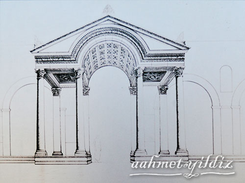
The Hadrianus Arch
The Hadrianus’ Arch situated to the north of oval shaped Hellenistic City Towers, at the start of Perge’s Columned Main Street, is of two storeys with three arches. As evidence of its name, this monumental gate was constructed during the reign of the Emperor Hadrianus (117-138 AD) by Plancia Magna, who held the titles: “the daughter of the city, Priestess of Arthemis, demiourgos, the mother of gods for the duration of life, pious and patriotic”.
From this structure rising from a podium, as is the case for many structures at Perge, only four of the gate’s pylons have survived to the present day. It has been understood from the inscription on the second storey of the gate over the middle arch that the Plancia Magna dedicated the construction of this monumental gate to the city.
It is known from the inscriptions in both the Latin and the Greek languages on this gate that it was decorated with statues of great beauty at the time it was constructed. According to these inscriptions, there were statues of members of the family of the gods including; Artemis Pergaia, Tykhe, Diva Matidia and Emperors such as Divus Augustus, Divus Nero, Divus Traianus, Hadrianus, Mariaina, Plotina, and Sabina as their spouses, stood on this gate. Together with its artistic beauty in workmanship and design, the ornamentation of this gate also served explicit political purposes through carrying the statues of Hadrianus and his family and the Roman emperors without “Damnatio Memoriae” (Damnation of Memory).
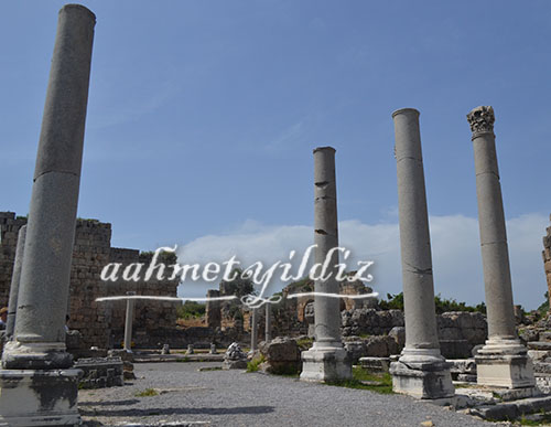
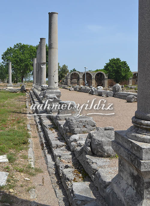
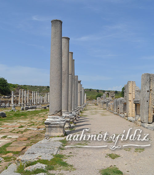
The Columned Main Street
In Perge, there are two columned streets that divide the city into four and intersect each other in the north, and with other main streets extending in a north-south and east-west direction in the lower town. As the main artery of the city in the north-south direction, the Columned Main Street extends for nearly 480.00 m. from Hadrianus Arch in the south to the Nymphaion of Kestros (F3) at the foot of the slope of the Acropolis in the north. The street extends not on a simple straight line but with four small variations. The reason for these changes is given to the existence of the public buildings standing on the route of the street prior to the construction of the street and pre-existing street of Hellenistic Period. This street also continues toward the unexcavated area in the south.
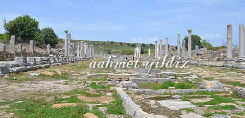
Nearly 22 m. wide this street is suitable for both pedestrians and vehicles and their wheel marks can be seen worn into the completely paved yellowish limestone surface of the street. There are porticos on the street, 6.50 m. wide on the west and 5.50 m. on the east side of the street. The floors of these porticos have mosaic tiling in geometric patterns made of colourful tesserea of limestone, marble and terracotta. Behind these porticos, there are stores. The bases of the columns are without exception carved from Prokonnesos marble in the Attic-Ionic style. The pedestals are carved from limestone and they are usually of square or rectangular shaped, however there are also octagonal examples. The stores behind the porticos have a length of 5.00 m. They have profiled door frames 2.50 m. high, 0.50 m. lintels and 3.00 m. high entrances. There is a unique open water channel in the middle of the street that extends with the descending ground level from north to south.
At the time it was constructed, the water flowed beneath the Kestros statue on the the Nymphaion of Kestros (F3) at the foot of the slope of the Acropolis, to fill the nymphaion pool. It flowed into the channel attached to the pool then to the south along the channel constructed in the middle of the street. After an interruption at the intersection, it continues from the beginning of the street that goes to the south and ends at the beginning of Tacitus Street to the south of Hadrianus’ Gate. However, research in recent years showed the channel continues in parallel to the Columned Main Street beyond the Roman Gate in the south. The outer part of the channel was made of limestone and it is 2.00 m. wide and has depth of between 0.78 and 1.20 m. The base of the channel was lined with large limestone plaques. Inside the channel was divided into compartments with limestone blocks rising to the upper limit in every 8.00 m. The function of this repeated change in level is thought to have been to lessen the rate of flow, enabling the dirt sink to the bottom, and thereby providing cleaner water throughout the length of the channels course through the city. Small bridges were constructed to enable passage for pedestrians across the channel which divides the street into two. These were made in a planned manner corresponding to the side streets that intersect this main street. There is also a waste water channel of the city directly beneath this channel. It is thought that this I street was planned together with the monumental structures at either end of it in the period of major construction works carried out in the city in first half of the 2nd century AD under Emperor Hadrianus.
Geef een reactie